In the approximately 4.6 billion years of the Earth’s existence, the surface has been continuously created, modified and destroyed. This is due to the fact that rocks are continually changing from one type of rock to another and back again as forces inside the Earth bring them closer to the surface (where they are weathered, eroded and lithified) and forces on the Earth sink them back down (where they are heated, compacted and melted). Therefore, the elements that make up rocks are never created or destroyed, but instead, are constantly being recycled (U.S. Geological Survey [USGS], 2014c).
Geology

There are three types of rock incorporated in this process:
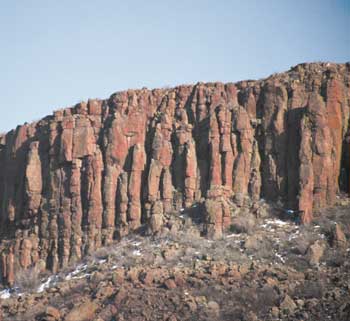
Igneous rocks form through the cooling and solidification of magma or lava, and may form with or without crystallization. The rock is referred to as “intrusive” or “plutonic” if the magma solidifies underground, and it is referred to as “extrusive” or “volcanic” if the lava solidifies on the Earth’s surface (Colorado Geological Survey [CGS], n.d.a). Examples of intrusive/plutonic igneous rocks include gabbro, granite and diorite, and can be found in most central mountain areas of Colorado, such as Pikes Peak and Longs Peak. Examples of extrusive/volcanic igneous rocks include basalt, obsidian and pumice, and can be found in volcanic areas of Colorado, such as the San Juan Mountains and Spanish Peaks (CGS, 1972).
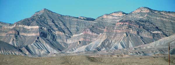
Sedimentary rocks begin to form when sediments are broken off of other rocks and carried by wind, water and gravity from higher to lower elevations until deposited in a resting place (deposition). As sediment accumulates in one area, depositional layers typically form that become compressed and sink into the crust under their own weight where temperatures are higher. Over time, this causes the layers to begin to compact and cement together to form a solid aggregate rock (clastic sedimentary). Sedimentary rocks can be found throughout much of Colorado’s plains, plateaus and mountain flanks (CGS, 1972). Although sedimentary rocks cover the majority of the Earth’s surface (approximately 75%), they only account for approximately 5% of the Earth’s crust (McKinney, Schoch & Yonavjak, 2012).
There are three basic types of sedimentary rocks: clastic, chemical and organic. Clastic rocks are formed by sediment from weathered pre-existing rocks that is transported to a depression where it is trapped, compacted and cemented. Examples of clastic sedimentary rocks include shale, siltstone and sandstone. Chemical sedimentary rocks form through the process of chemical precipitation. Water traveling through rock dissolves some of the minerals and carries them away from the rock where they can eventually be redeposited (precipitated) when the water evaporates or becomes oversaturated with minerals. Examples of chemical sedimentary rocks include rock salt, trona and chert. Organic sedimentary rocks form when organic material (dead plants, animal shells, etc.) are compressed and cemented over time to form rock. Examples of organic sedimentary rocks include coal, some limestone and fossiliferous rocks (CGS, n.d.b; USGS, 2014b).
Metamorphic rocks form from other pre-existing rocks (igneous, sedimentary or earlier metamorphic) whose chemical and/or physical properties have transformed, or “morphed”, because of intense heat and pressure from deep burial in the Earth (McKinney, Schoch & Yonavjak, 2012). There are two basic types of metamorphic rocks, foliated and non-foliated/granular, which are both located in the mountain regions of Colorado. Foliated metamorphic rocks have a parallel arrangement of mineral grains that provide a striped (foliated) appearance caused by high heat and directional pressure. The layers formed reflect the direction in which pressure was applied, as can be seen in gneiss, schist and slate. Non-foliated, or granular, metamorphic rocks are generally uniform in composition so the minerals do not separate into layers like foliated metamorphic rocks do under intense heat and pressure. Examples of non-foliated metamorphic rocks include marble, quartzite and amphibolite (USGS, 2014a).
All three types of rock are found throughout Colorado, formed in different areas over the history of the region based on different geologic events.
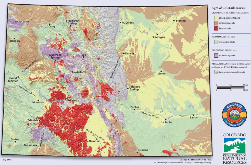
Colorado’s rocks provide us a geologic story of multiple structural events raising mountain ranges that are later eroded and partially buried in their own debris, shallow seas with their beaches sweeping across the land, deserts swelling with dune fields, large active volcanic fields that seared a land dominated by deltas and swamps, and landscape modification by glaciers (CGS, 2002). For example, magma pushed its way upward and cut into pre-existing rock layers to form the core of the Rocky Mountains running through the state. In the plains, most regions used to be under an inland sea, so sediments that slowly accumulated on the bottom were cemented into sedimentary rock. The western plateau region tells of gradual uplifting and folding, and the power of water in sculpting the sedimentary layers into numerous mesas. See the tables below for an overview of which events created different types of rocks and formations, and the figures above for where they are located throughout the state.
The following table depicts the geologic time scale and highlights the major geologic events occurring within Colorado.
| Era | Period | Millions of Years Ago | Events & Geologic Deposits | Features |
|---|---|---|---|---|
| Cenozoic | Quaternary | 1.8 | Development of present topography; Neoglaciation (small cirque glaciers); Altithermal phase (warming); Ice Age (large valley glaciers in mountains) Dune, wind, landslide, glacial deposits | Great Sand Dunes; widespread faulting |
| Tertiary | 65 | Uplift (to present elevations) and mountain-building; Laramide Orogeny (major canyon cutting); San Juan and Thirty Nine Mile Volcanic Fields White River Formation (ash and many mammal fossils), Denver Formation, Arapahoe Conglomerate, Dawson Arkose (delta and river sediments) | Florissant fossil beds; San Juan Mtns. (largest volcanic area in Colorado); rich mineral deposits | |
| (K-T boundary) | Asteroid impact causes worldwide extinction of plants and animals | End of dinosaurs | ||
| Mesozoic (Age of Reptiles) | Cretaceous | 144 | Deep and shallow marine and swamp conditions Laramine Formation (interbedded sands and coal), Pierre Shale (fine gray muds), Niobrara Limestone, Benton Shale (black muds), Dakota Formation (beach and sand bars) | Oysters; oil in eastern Colorado; coal in western Colorado |
| Jurassic | 206 | Desert conditions; intermittent streams; brief submergence and "salt" flats Morrison Formation (streams), Ralston Creek Formation ("salt" flats), Navajo Sandstone (dune), Carmel Formation (stream), Entrada Sandstone (dune) | Dinosaurs; vanadium, radium, and uranium concentrations in organic materials | |
| Triassic | 248 | Desert conditions; mudflats; alluvial plains, dune fields Coastal plain, dune, or delta deposits; Lykins Formation | Early dinosaurs | |
| Paleozoic | Permian | 290 | Deep basins and deserts; Ancestral Rockies almost entirely removed by erosion Maroon Formation (red bed deposits) | Tracks of early reptiles in Lyons Formations |
| Pennsylvanian | 323 | Uplift of Ancestral Rockies; erosion of older sediments; shallow seas and evaporite basins Fountain, Hermosa, and Minturn Formations | Flatirons and Red Rocks Park | |
| Mississippian | 354 | Widespread open ocean then withdrawal of the sea Leadville Limestone, Molas Formation (soil/pebbles/chert) | Brachiopods, corals | |
| Devonian | 417 | Embayments of western sea covering much of Colorado; deposition of marine limestone; intrusion of kimberlite volcanics Parting Sandstone, Dyer Dolomite | Fossil fish, algae, brachiopods, mollusks, corals | |
| Silurian | 443 | Shallow seas and marine deposition | Corals, brachiopods | |
| Ordovician | 490 | Deepening and widening of sea; deposition of limestone and dolomite Manitou Formation, Harding Sandstone, Fremont Limestone | Earliest known vertebrate, agnathids (jawless fish) | |
| Cambrian | 543 | Invasion of the sea from the west and east Sawatch Quartzite (e.g. Glenwood Canyon) | First hard-shelled animals (e.g. trilobites) | |
| Precambrian | Accounts for more than 85% of geologic time | 4,600 | "Lipilian Interval" (long period of erosion) Pikes Peak Granite (pink, coarse-grained), Silver Plume Granite (light pinkish gray, fine-grained), Boulder Creek Granite (dark gray, faintly banded), Red Creek Quartzite | Front Range "core"; Early soft-bodied marine organisms |
| Recreated from Colorado Geological Survey (2003). | ||||
The table below details the Proterozoic to Holocene stratigraphy that spans the state’s many sedimentary basins. For an accessible version of this table, please contact the Colorado Geological Survey.

Topographic/Geologic Zones
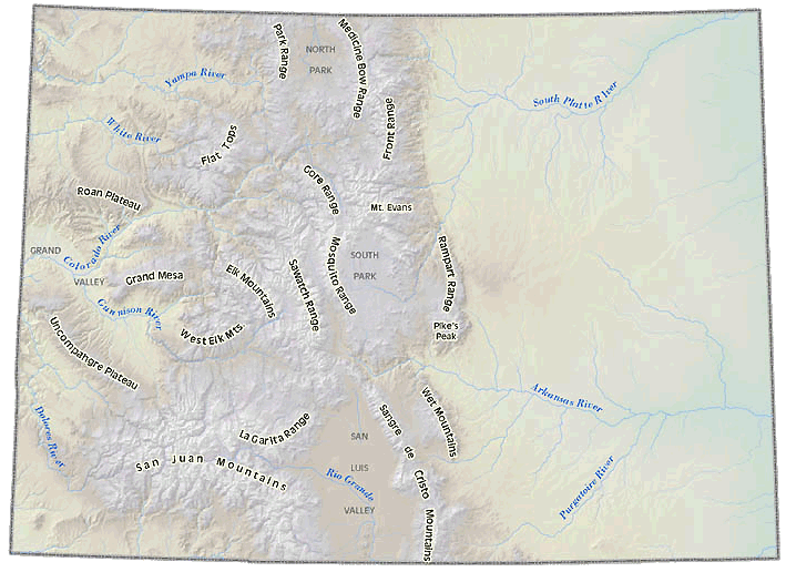
Colorado can generally be divided into three major topographic/geologic zones: the Colorado Plateau, Southern Rocky Mountains and the Great Plains.
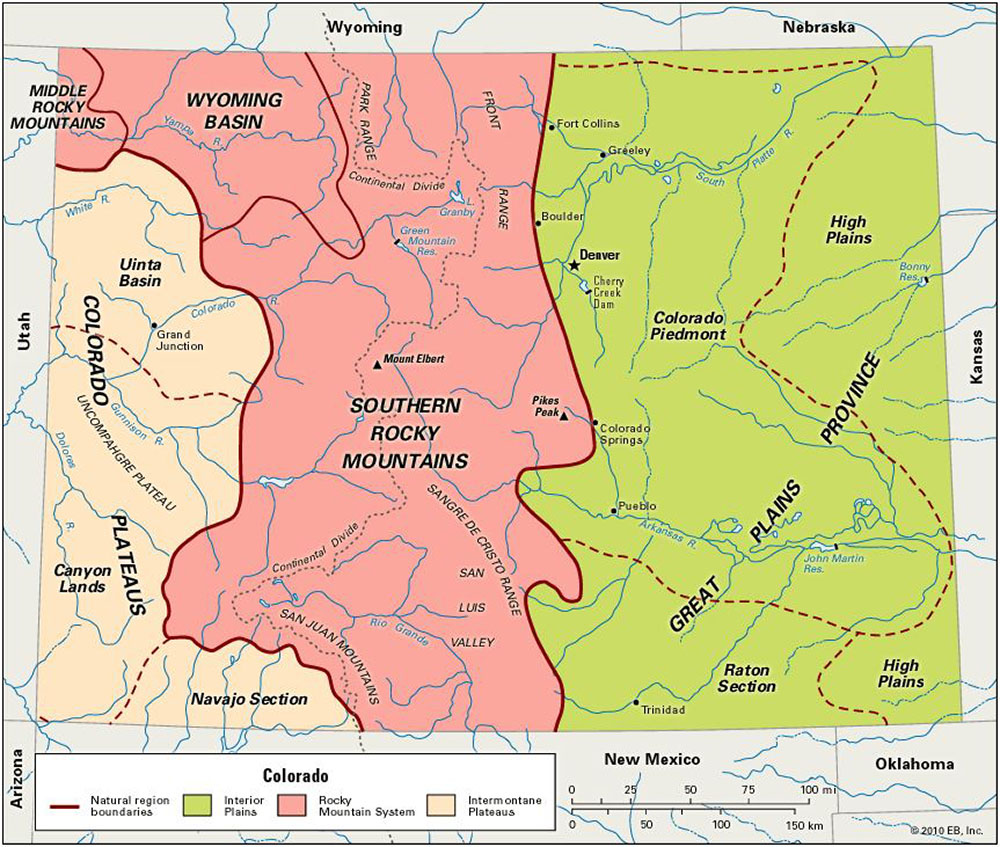
Located in the western quarter of the state, the Colorado Plateau region mainly consists of a succession of plateaus, mesas, mountains and canyons. Elevations range from 5,000 to 11,000 feet above mean sea level, with lower elevations toward the west away from the mountains and out into southern Utah and northern Arizona and New Mexico. The region contains several major landforms, including the White River Basin, Roan Plateau, Piceance Basin, Grand Mesa, Colorado National Monument, Uncompahgre Plateau, Paradox Basin and the San Juan Basin (Jones & Cech, 2009).
Paleozoic, Mesozoic and Cenozoic (543 million years ago to present) in age, the region is composed of mainly flat-lying sedimentary rock from numerous episodes of deposition. While the Rockies were being formed by repeated uplift and erosion, faulting and folding, magma intrusions and burying by volcanic eruptions, the Colorado Plateau region remained relatively stable. This region was gradually uplifted and gently folded during the Laramide Orogeny, which constructed much of the landscape structure present today (Hopkins & Hopkins, 2000). After the Laramide Orogeny within the past ten million years, this plateau region was cut and sculpted by the Colorado River and its tributaries. Beginning first with the softer, more easily erodible rocks such as shale, and then moving on to the more resistant rocks as a result of a regional uplift during the late Cenozoic Era, the rivers began removing large volumes of sedimentary rocks and carving broad valleys and canyons. The process of erosion continues to wear down the exposed, colorful (mainly sedimentary) layers of this region today, as is evidenced by the exposure of Mesozoic and now Precambrian rocks in the canyons on the northeastern edge of the Uncompahgre Plateau at Colorado National Monument (National Park Service [NPS], 2005).
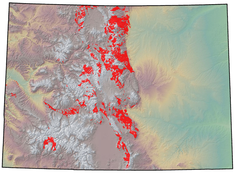
The Southern Rocky Mountain region runs north-south through the center of the state. This region consists of several distinct mountain ranges with elevations ranging from 6,000 feet to over 14,000 feet. The Continental Divide, which separates all water flowing towards the Pacific Ocean from all that is flowing towards the Atlantic and Arctic Oceans and Gulf of Mexico, is formed by the crests of several of these ranges. The Colorado Rockies are home to over 54 peaks that exceed 14,000 feet, and some of its major mountain ranges include the Front Range, Wet Mountains, Sangre de Cristo Range, Spanish Peaks, Park Range, Sawatch Range and the San Juan Mountains. Mt. Elbert, located in the Sawatch Range, is the highest peak in the state reaching elevations of 14,439 feet above sea level (Jones & Cech, 2009). All of the state’s major rivers (the Colorado, Arkansas, Rio Grande, South Platte and White/Yampa) originate high in the Rockies.
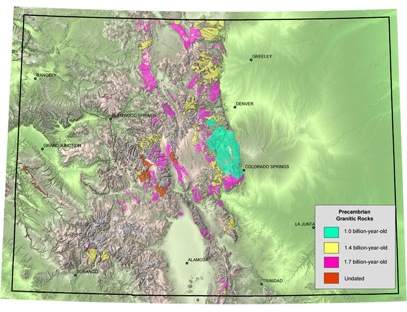
Ancient Proterozoic Precambrian rocks over 1.7 billion years old form the core of the Rocky Mountains through Colorado. The mountain core is formed of schists and geneisses which were originally comprised of mainly sedimentary (shale, siltstone and sandstone) and some earlier volcanic materials. These sedimentary parent rocks were recrystallized into metamorphic rocks (schist and gneiss) by enormous heat and pressure resulting from a collision induced by plate tectonics. These high-elevation Proterozoic mountains were slowly eroded to a nearly flat surface, exposing the core of the metamorphic rocks and igneous granite. Approximately 500 million years ago this flat area became covered by shallow seas and then deposited with Paleozoic sedimentary rocks over the next 200 million years. Another mountain uplift event occurred about 300 million years ago forming the “Ancestral Rocky Mountains” during the Pennsylvanian Period, followed by erosion of the Paleozoic Period sediments. From the middle of the Permian Period to the end of the Cretaceous Period about 65 million years ago, erosion and intermittent coverage by seas continued (Griffin, 2014).
Collision of major tectonic plates began about 130 million years ago along the southwestern edge of North America, causing uplift and the creation of the current day Colorado Rocky Mountains about 70 million years ago. During this period of uplift, known as the Laramide Orogeny, the Cretaceous Sea withdrew, the thick top sedimentary layer eroded and the Proterozoic igneous and metamorphic rocks were again exposed for erosion. Deep fault zones formed allowing granitic magmas to rise into what is now known as the Never Summer Mountains on the west side of Rocky Mountain National Park. About 29-24 million years ago, the magmas reached the surface and erupted as volcanoes (Griffin, 2014). During the end of the Tertiary Period and entering the Quaternary Period, the entire state experienced a long period of general uplift, bringing the mountains to their present elevations. The Laramide Orogeny and following Tertiary Periods are also responsible for the development of some of the major basin and down-warped features between the mountain ranges, including North, Middle and South Parks, the Raton Basin, Wyoming Basin, Piceance Basin and the San Juan Basin (Lufkin, 2006).
The Quaternary Period (2.6 Ma – present) is characterized by periods of glaciation. Glaciers eroded deep mountain valleys and deposited large volumes of sediment on the valley bottoms. Melting ice produced large rivers below 8,000 feet during this time that were loaded with glacial debris and began ‘canyon cutting’ along mountain fronts and basins. Although mountain-building appears to have climaxed during the Tertiary Period, there is evidence that volcanism has occurred within the last few thousand years, as well as faulting within the last few hundred years (CGS, 1972).
Covering nearly 40 percent of the state, the Great Plains of Colorado begin at an elevation of 5,000 – 6,000 feet near the eastern border of the Rockies and slope down to Kansas at 3,350 feet elevation. Composed of generally flat-lying sedimentary rock, exposed surface rocks on the Great Plains are Cretaceous, Tertiary and Quaternary in age (Lufkin, 2006). These layers of sandstone, shale and limestone were originally formed on the bottom of shallow seas that covered the state a number of times throughout the history of the North American continent. Deep below these sedimentary layers are igneous and metamorphic rocks composed of granite, schist and gneiss, known as the Precambrian or “basement” rock, which are remnants of mountains that existed approximately one billion years ago (CGS, 1972).
Colorado’s Great Plains contain three major landforms: High Plains, Colorado Piedmont and the Raton Basin.
- The High Plains are prairie lands stretching from Wyoming down to Oklahoma, and include four major topographic features: the South Platte River, Arkansas River, Purgatoire River and Palmer Divide.
- The Colorado Piedmont is an area along the base of the foothills of the Front Range in north central Colorado located just under 5,000 feet elevation. The area is characterized by a broad, hilly valley stretching north and northeast of Denver in the South Platte River valley and southward from Colorado Springs in the Arkansas River valley.
- The Raton Basin is a geologic structural basin in southern Colorado and northern New Mexico that is bound by the Sangre de Cristo Mountains and Culebra Range to the west, the south edge of the Wet Mountains to the north, the Apishapa Arch to the northeast, the Las Animas Uplift to the east and the Sierra Grande uplift to the south and southeast. The lowest elevation is approximately 6,000 feet along the Purgatoire River, while the highest elevation rises to over 13,600 feet at the Spanish Peaks.
Hydrogeology of Colorado
An aquifer is a groundwater reservoir composed of geologic units that are saturated with water and sufficiently permeable to yield water in usable amounts to wells and springs. Geologic units comprising an aquifer consist of either unconsolidated sediments or consolidated rock, with the porosity of the rock determining the amount of water it can hold and its permeability determining its ability to transmit water (Figure 9). Two important functions are provided by aquifers: 1) transmitting groundwater from areas of recharge to areas of discharge; and 2) providing a storage medium for useable quantities of groundwater (CGS, 2002, 2003). The USGS identifies seven principal aquifers or aquifer systems in Colorado: the South Platte Aquifer, Arkansas Aquifer, High Plains Aquifer, San Luis Valley Aquifer System, Denver Basin Aquifer System, Piceance Creek Basin Aquifer and the Leadville Limestone Aquifer of west-central Colorado (CGS, 2003).

Based on their geologic materials, Colorado’s principal aquifers are categorized into four types:
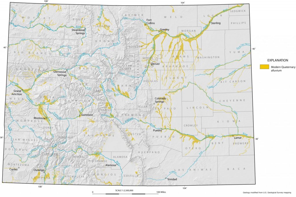
Alluvial aquifers associated with Colorado’s major river systems are unconfined and generally consist of unconsolidated silt, sand and gravel that has been deposited during the Quaternary Period by rivers. These alluvial aquifers contain groundwater stored in unconsolidated sediment along river valleys. Alluvial aquifers typically interact with the associated stream surface water and may exhibit seasonal variation in response to surface-water flow (CGS, 2004, 2006). Colorado’s alluvial aquifers may also contain perched or confined groundwater if clay layers are present in the stream sediments (CGS, 2003). The unconsolidated alluvial aquifers associated with the major river systems are mainly used for domestic, agricultural and/or municipal purposes, with those composed of sand and gravel deposits containing the highest yields in the state due to high porosity and permeability (CGS, 2004).
Colorado’s consolidated sedimentary rock aquifers are deep and composed of clastic and carbonate deposits, with the major sedimentary aquifers consisting predominantly of sandstones and limestones of varying age. Many of these aquifers are located in structural basins that contain multiple geologic units and aquifers. Groundwater in these aquifers can be either confined or unconfined, and large quantities of groundwater can occur in deep basins, such as the Denver Basin aquifer (CGS, 2003). The state’s basin-wide aquifer systems include the Denver, Piceance, Paradox, San Juan, Eagle, Raton and Sand Wash Basin, and North, Middle, South and Huerfano Park (CGS, 2002).
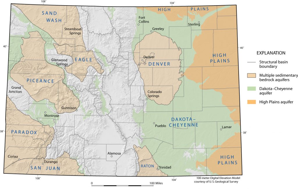
Chiefly derived from erosion of surrounding highlands, unconsolidated to poorly consolidated sediments were deposited by water, wind and gravity to form Colorado’s various, often localized, alluvial fans, landslide and eolian deposits (CGS, 2004). These unconsolidated to poorly consolidated sediments create a network of hydraulically connected aquifers within valley-fill deposits of the intermontane valleys containing similar hydraulic characteristics to alluvial aquifers, with the exceptions of slightly lower permeability and thickness (can be hundreds of feet thick) (CGS, 2004, 2006). The state’s Great Plains region is also underlain by thick layers of gravel, sand, silt and clay eroded from the Rockies. Colorado’s unconsolidated to poorly consolidated aquifers include the San Luis Valley, Wet Mountain Valley and Ogallala Formation of the High Plains Aquifer (CGS, 2002, 2004).

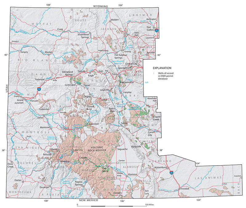
Colorado’s crystalline rocks are Precambrian-aged igneous and metamorphic (granite, gneiss, schist), as well as Tertiary aged volcanic and igneous intrusive (granite, pegmatite). Occupying approximately 19 percent of the state’s total area, these rocks can be found exposed at the surface of the mountainous, west-central portion of the state, with the younger Tertiary volcanic igneous rocks found west of and between the outcrops of Precambrian rocks (CGS, 2002, 2003, 2006). Groundwater in crystalline-rock aquifers is generally unconfined and occurs where fractures and faults have crosscut the rock. These crystalline-rock aquifers supply much of the domestic water-supply needs in the mountainous portion of the state (CGS, 2003).

Geologic Activity: Rocky Mountain National Park, Colorado by the National Park Service (2007).
The website provides a brief, albeit more detailed than above, description of the geologic history of Rocky Mountain National Park. While the focus is Rocky Mountain National Park, the website also provides details on the entirety of the Rockies throughout Colorado.
Geology of Colorado and Major Prehistoric Events by John L. Lufkin (2006).
The journal article provides an in-depth description of the basic geologic framework for the state of Colorado. It contains descriptions of the major physiographic provinces, the origin of fundamental rocks and a discussion of the distribution of major rock types and structures.
Groundwater atlas of Colorado (Colorado Geological Special Publication 53) prepared by R. Topper, K.L. Spray, W.H. Bellis, J.L. Hamilton, and P.E. Barkmann (2003).
The Ground Water Atlas of Colorado is a comprehensive reference of the state’s ground-water resources: summarizing the location, geography, geology, water quality and hydrologic characteristics of its major aquifers.
Prairie, Peak and Plateau: a guide to the geology of Colorado (Colorado Geological Survey Bulletin 32) prepared by J. Chronic & H. Chronic (1972).
A detailed guidebook of Colorado’s geology and its relationship to humans.
Rocky Mountain National Park Geologic Resource Evaluation Report by the National Park Service, Geologic Resources Division (2004).
Provides a detailed account of the geologic features, processes and issues of Rocky Mountain National Park in Colorado more specifically, as well as for the state of Colorado more generally.
Colorado Geological Survey [CGS]. (n.d.a). Igneous Rocks.
—–. (n.d.b). Sedimentary Rocks.
—–. (1972). Prairie, Peak and Plateau: a guide to the geology of Colorado (Colorado Geological Survey Bulletin 32). Prepared by J. Chronic & H. Chronic. Denver, CO: Colorado Geological Survey.
—–. (2002). Groundwater in Colorado – A Primer. Rock Talk, 5(4). Denver, CO.
—–. (2003). Groundwater atlas of Colorado. (Colorado Geological Survey Special Publication 53). Prepared by R. Topper, K.L. Spray, W.H. Bellis, J.L. Hamilton, and P.E. Barkmann. Denver, CO: Colorado Geological Survey.
—–. (2004). Artificial Recharge of Groundwater in Colorado – A Statewide Assessment (Environmental Geology 13). Prepared by R. Topper, P.E. Barkmann, D.A. Bird & M.A. Sares. Denver, CO: Colorado Geological Survey.
—–. (2008). Generalized geology of Colorado [Map].
CSU Natural Resources Ecology Lab. (n.d.). Major Ranges & Rivers in Colorado [Map].
Encyclopedia Britannica Online. (n.d.). Natural regions of Colorado [Map].
Griffin, K. (2014). Geology Teacher Guide to Rocky Mountain National Park. National Park Service Educational Resources.
Hopkins, R. L., & Hopkins, L. B. (2000). Hiking Colorado’s Geology. Seattle, WA: The Mountaineers Books.
Mineralogical Society of America. (2015). The Rock Cycle [Figure]. Mineralogy4kids.
Lufkin, J. L. (2006). Geology of Colorado and Major Prehistoric Events. GEO-Volution, 1-17. Biennial Geotechnical Seminar 2006.
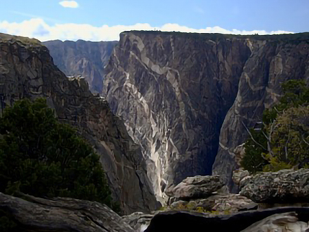
McCreary, J. (n.d.) The Painted Wall of the Black Canyon of the Gunnison [Figure]. Cliffshade.
McKinney, M. L., Schoch, R., & Yonavjak, L. (2012). Environmental Science: Systems and Solutions (4th ed.). Burlington, MA: Jones & Bartlett Learning.
National Park Service [NPS]. (2005). Geology Fieldnotes: Colorado National Monument, Colorado.
Raynolds, R. G., & Hagadorn, J. W. (2016). Colorado Stratigraphy Chart. Map Series MS-53. Denver, CO: Colorado Geological Survey and the Denver Museum of Nature & Science.
U.S. Geological Survey [USGS]. (2014a). Metamorphic Rocks. Geologic Tour.
—–. (2014b). Sedimentary Rocks. Geology and National Parks.
—–. (2014c). The Age of the Earth. Geology and National Parks.