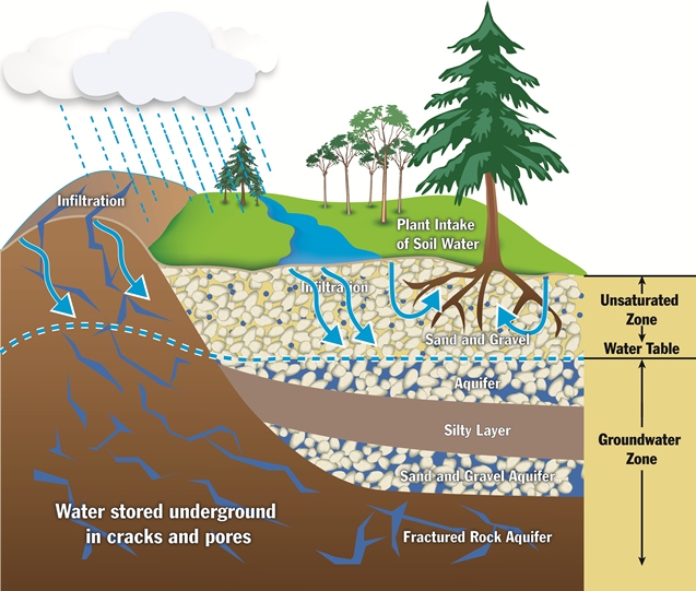
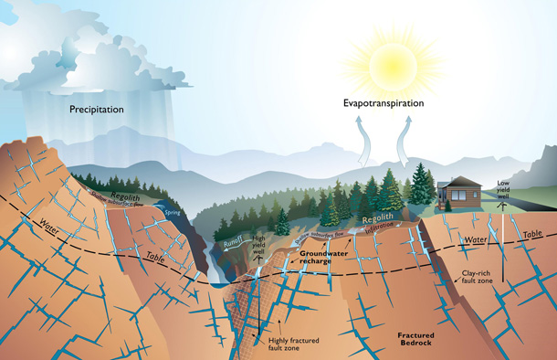
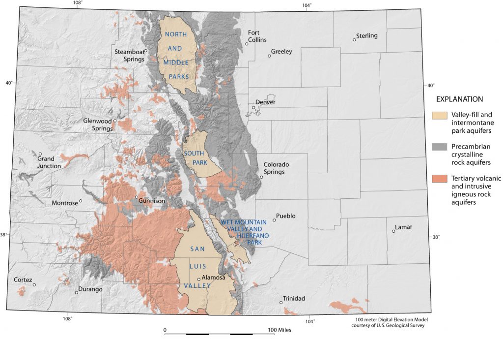
Groundwater is the water found beneath the Earth’s surface and occupies the very small cracks and spaces between rocks, gravel and sand. It is a common misconception that groundwater is in the form of underground lakes, streams and rivers, when in reality, groundwater is found inside rocks: in the small pore spaces between rock grains in sedimentary rocks, between sand and gravel particles in alluvial deposits, or in narrow fractures and faults in crystalline rocks (Water Education Colorado [WEco], 2005, 2007; Colorado Geological Survey [CGS], 2002, 2003).

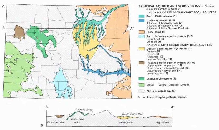
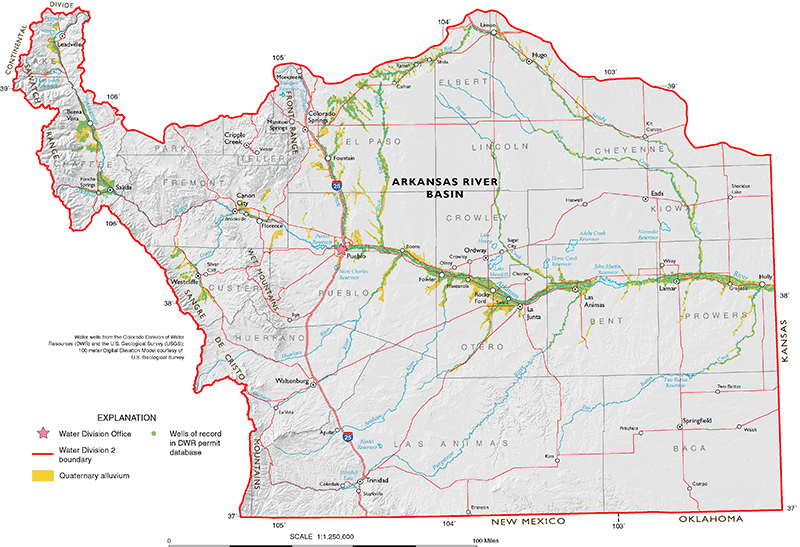
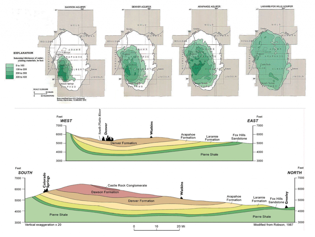
Groundwater supplies are available throughout much of Colorado; however, while most of state’s surface water resources are found west of the Continental Divide, most of the state’s groundwater resources lie to the east of the Divide (Grigg, 2003; Pearl, 1980). Of Colorado’s 64 counties, 19 rely heavily on the state’s groundwater resources, with private wells and public water supply systems serving approximately 20% of the population. (CGS, n.d., 2002; State of Colorado, 2015). Agriculture also heavily relies on groundwater, mainly for irrigation, but also for livestock and rural domestic needs (CGS, n.d.).

Diagram of groundwater and surface water interactions.
Groundwater Diagram. Department of Environment & Conservation, Government of Newfoundland & Labrador (2016).

Types of Groundwater

In Colorado, groundwater is classified as one of the following types for management and allocation purposes (WEco, 2015; Colorado Water Conservation Board [CWCB], 2011; Jones & Cech, 2009; Nichols, Murphy & Kenney, 2001):

Groundwater that is hydrologically connected to a surface stream and which has the ability to influence the amount or direction of flow of water in that stream is referred to as tributary. In Colorado, all groundwater is presumed to be tributary to a surface stream (unless otherwise defined) and is treated like surface waters under the prior appropriation doctrine administered by the Office of the State Engineer.

Diagram showing how streams can either discharge to groundwater or be recharged by groundwater.
Streams may either discharge to groundwater or be recharged by groundwater. CGS (2003).

While tributary groundwater is hydrologically connected to a surface stream, non-tributary lacks this direct connection. Non-tributary groundwater, located outside of any designated groundwater basin, is defined by Colorado as groundwater where the withdrawal of will not, within 100 years, deplete the flow of a natural stream at an annual rate greater than one-tenth of one percent of the annual rate of withdrawal. Because these waters are hydrologically distinct from surface streams and accompanying alluvial aquifers, they are allocated on the basis of overlying land ownership, instead of prior appropriation, with the Office of the State Engineer overseeing permitting and administration.

Designated groundwater is a type of non-tributary groundwater, so under natural conditions, it does not recharge or supplement to any significant degree continuously flowing surface streams. This type of groundwater is found in designated basins, which are areas in the eastern plains with very little surface water where users rely primarily on groundwater as their source of supply. In 1965, the state Legislature authorized the Colorado Ground Water Commission to create designated groundwater basins through the 1965 Ground Water Management Act. The 1965 Act created a modified prior appropriation system for designated groundwater where the Colorado Ground Water Commission is responsible for issuing well permits, while the Commission, State Engineer and local Ground Water Management Districts administer them. There are currently eight of these designated basins on the eastern plains and 13 Ground Water Management Districts within the designated basins.

Groundwater located within one of the aquifers within the Denver Basin Aquifer System: Dawson, Denver, Arapahoe and Laramie-Fox Hills aquifers. This aquifer system is located along Colorado’s eastern slope between Greeley and Colorado Springs. There are two types of groundwater with the Denver Basin, both allocated according to overlaying land ownership, with the State Engineer overseeing permitting and administration:

  • Non-Tributary Groundwater: As described above, non-tributary groundwater does not significantly impact flows in a natural stream due to the lack of a hydraulic connection (the withdrawal will not, within 100 years, deplete the surface flow of a natural stream at an annual rate greater than one-tenth of one percent of the annual rate of withdrawal). Use of non-tributary groundwater in the Denver Basin Aquifer System requires relinquishment of two percent of the water pumped.
  • Not Non-Tributary Groundwater: While the hydraulic connection is not as significant as tributary groundwater, not non-tributary groundwater do influence surface streams due to their locality. Withdrawals of not non-tributary groundwater within one of the Denver Basin aquifers requires at least four percent of the water pumped to be returned to the surface streams, and in some cases, actual replacement of depletions.
Map depicting the location of the Denver Basin Aquifer System.
Location of Denver Basin Aquifer System. CGS (2003).

All subsurface geothermal fluids are considered part of Colorado’s groundwater resources. Geothermal water is groundwater that is heated by the earth’s energy, and by harnessing the physical properties of steam and heat, geothermal water can be used to generate energy. Subject to the Colorado Geothermal Resources Act, use of the state’s subsurface geothermal resources requires a permit from the State Engineer.

Interpretive geothermal heat flow map of Colorado.
Geothermal Heat Flow Map of Colorado. CGS (2007).

Exempt Wells

Exempt wells are somewhat of a “wild card” in Colorado groundwater law, because they are allowed in tributary, nontributary, not nontributary and designated groundwater aquifers, but are not subject to the rules of allocation and administration of those other types of groundwater. Exempt wells are small-capacity wells (typically 15 gallons per minute) for domestic, stock-watering and low-intensity commercial uses in locations where other supplies are not available (Jones & Cech, 2009). Two statutes address govern exempt wells: C.R.S. 37-92-602 for exempt wells outside of designated basins, and C.R.S. 37-90-105 for exempt wells inside designated basins. The State Engineer is responsible for processing exempt well applications and granting the well permits.

Diagram of a typical private water supply system.
Typical Private Well & Water Supply System. Marx, Waskom & Wolfe (2013).

Aquifers

Precipitation that does not runoff into rivers, is not absorbed by plants or lost to evaporation, percolates down into the soil and is stored in geologic formations called aquifers. An aquifer is a groundwater reservoir composed of geologic units that are saturated with water and sufficiently permeable to yield water in usable amounts to wells and springs. Geologic units comprising an aquifer consist of either unconsolidated sediments or consolidated rock, with the porosity of the rock determining the amount of water it can hold and its permeability determining its ability to transmit water (CGS, 2002, 2003).

When precipitation occurs over land, a portion is able to infiltrate into the subsurface. Then, a share of that portion is able to continue percolating downward through the soil until it reaches saturated rock below the water table. This process is known as groundwater recharge and occurs at varying rates depending upon the porosity and permeability characteristics of the underground rocks, as well as water availability for natural recharge (U.S. Geological Survey [USGS], 2016; Waller, 1988). Two important functions are provided by aquifers: 1) transmitting groundwater from areas of recharge to areas of discharge; and 2) providing a storage medium for usable quantities of groundwater (CGS, 2002, 2003).

Diagram of the porosity and permeability of Colorado's four common geologic units that form aquifers.
Porosity & permeability of common geologic units that form aquifers in Colorado. CGS (2003).

Types of Aquifers

Based on their geologic materials (visit the Geology web page for more details), Colorado’s principal aquifers are categorized into four types:

Alluvial aquifers associated with Colorado’s major river systems are unconfined and generally consist of unconsolidated silt, sand and gravel that has been deposited during the Quaternary Period by rivers. These alluvial aquifers contain groundwater stored in unconsolidated sediment along river valleys, and as a result, are often referred to as “tributary aquifers” because they typically interact with the associated stream surface water and may exhibit seasonal variation in response to surface-water flow (WEco, n.d.; CGS, 2004, 2006). Colorado’s alluvial aquifers may also contain perched or confined groundwater if clay layers are present in the stream sediments (CGS, 2003). The unconsolidated alluvial aquifers associated with the major river systems are mainly used for domestic, agricultural and/or municipal purposes, with those composed of sand and gravel deposits containing the highest yields in the state due to high porosity and permeability (CGS, 2004). Over-pumping of these types of aquifers can result in a decline of water in nearby rivers and lakes.

Map showing the location of major Quaternary-age alluvial deposits in Colorado.
Colorado's major Quaternary-age alluvial deposits. CGS (2003).

Chiefly derived from erosion of surrounding highlands, unconsolidated to poorly consolidated sediments were deposited by water, wind and gravity to form Colorado’s various, often localized, alluvial fans, landslide and eolian deposits (CGS, 2004). These unconsolidated to poorly consolidated sediments create a network of hydraulically connected aquifers within valley-fill deposits of the intermontane valleys containing similar hydraulic characteristics to alluvial aquifers, with the exceptions of slightly lower permeability and thickness (can be hundreds of feet thick) (CGS, 2004, 2006). The state’s Great Plains region is also underlain by thick layers of gravel, sand, silt and clay eroded from the Rockies. Colorado’s unconsolidated to poorly consolidated aquifers include the San Luis Valley, Wet Mountain Valley and Ogallala Formation of the High Plains Aquifer (CGS, 2002, 2004).

Map of the location of poorly consolidated to unconsolidated aquifers in Colorado.
Poorly consolidated to unconsolidated aquifers in Colorado. Map created from Colorado's Decision Support Systems Map Viewer (Copyright 2005 by Division of Water Resources).

Colorado’s consolidated sedimentary rock aquifers are deep and composed of clastic and carbonate deposits, with the major sedimentary aquifers consisting predominantly of sandstones and limestones of varying age. Many of these aquifers are located in structural basins that contain multiple geologic units and aquifers. Groundwater in these aquifers can be either confined or unconfined, and large quantities of groundwater can occur in deep basins, such as the Denver Basin aquifer (CGS, 2003). The state’s basin-wide aquifer systems include the Denver, Piceance, Paradox, San Juan, Eagle, Raton and Sand Wash Basin, and North, Middle, South and Huerfano Park (CGS, 2002).

Map of the location of Colorado's major sedimentary rock aquifers & structural basins.
Location & extent of Colorado's major sedimentary rock aquifers & structural basins. CGS (2003).

Colorado’s crystalline rocks are Precambrian-aged igneous and metamorphic (granite, gneiss, schist), as well as Tertiary aged volcanic and igneous intrusive (granite, pegmatite). Occupying approximately 19 percent of the state’s total area, these rocks can be found exposed at the surface of the mountainous, west-central portion of the state, with the younger Tertiary volcanic igneous rocks found west of and between the outcrops of Precambrian rocks (CGS, 2002, 2003, 2006). Groundwater in crystalline-rock aquifers is generally unconfined and occurs where fractures and faults have crosscut the rock. These crystalline-rock aquifers supply much of the domestic water-supply needs in the mountainous portion of the state (CGS, 2003).

Conceptual diagram of an aquifer system in fractured, crystalline rock.
Conceptual Model of an aquifer system in fractured, crystalline rock. CGS (2003).
Map depicting the volcanic & crystalline rock aquifers located within Colorado.
Volcanic & crystalline rock aquifers in Colorado. CGS (2003).

Colorado’s Principal Aquifers

The USGS identifies seven principal aquifers or aquifer systems in Colorado: the South Platte Aquifer, Arkansas Aquifer, High Plains Aquifer, San Luis Valley Aquifer System, Denver Basin Aquifer System, Piceance Creek Basin Aquifer and the Leadville Limestone Aquifer of west-central Colorado (CGS, 2003). The following information was compiled mainly from CGS (2003), with additional details from Coffin, Welder & Glansman (1971), Jones & Cech (2009), McCalpin, Funk & Mendel (2012), Pearl (1980), Robson & Banta (1995) & USGS (1986).

Map of the principal aquifers throughout the state of Colorado.
Colorado’s Principal Aquifers. USGS (1986).

Type: Unconsolidated alluvial

Composition: The upper basin (river upstream of Pueblo) is composed of unconsolidated river-deposited sediments of varied sizes (glacial silts to large boulders). The lower basin (downstream of Pueblo) is composed of a heterogeneous mix of interbedded sands, gravels, silts and clays.

Size: Approximately 450 mi2

Thickness: Up to 100 feet in the upper basin and up to 250 feet in the lower basin

Saturated Thickness: 5-30 feet along much of the lower Arkansas River and its tributaries, and 5-58 feet in the Upper Arkansas River Basin

Water Levels: 5-58 feet in the upper basin and 5-30 feet in the lower basin

Uses: Primarily domestic purposes in the upper basin and agricultural in the lower basin

Other characteristics: In many areas of the upper basin, the alluvium is missing where the river is actively eroding in deep bedrock canyons. Exiting the mountain front west of Pueblo, the alluvium in the lower basin is more continuous – extending up to three miles across and essentially continuous to the state line with Kansas.

Map depicting the location of Arkansas Alluvial Aquifer.
Location of Arkansas Alluvial Aquifer. CGS (2003).

Type: Consolidated sedimentary rock, comprised of four aquifers (Dawson, Denver, Arapahoe and Laramie-Fox Hills)

Composition: Sandstones, siltstones and conglomerates interlayered with beds of mudstone and shale (see hydrogeologic units table for more details)

Size: Approximately 6,700 mi2 for the system (Dawson, 1,400 mi2; Denver, 3,500 mi2; Arapahoe, 4,700 mi2; Laramie-Fox Hills, 6,700 mi2)

Thickness: Maximum combined thickness of 3,200 feet for the system

Saturated Thickness: 0-400 feet, depending upon specific aquifer (see cross section diagram for details); the Denver, Arapahoe, and Laramie-Fox Hills aquifers are (for the most part) confined, so they are (for the most part) completely saturated

Water Levels: Generally range from 0-250 feet, but are 500-1,300 feet below the ground in parts of the deeper aquifers between Denver and Castle Rock

Uses: Municipal, domestic, commercial and agricultural uses

Other characteristics: Underlying the aquifer system is as much as 7,000 feet of nearly impermeable Pierre Shale. Underneath the Pierre Shale is the Dakota Sandstone, which is a source of water near the outcrop/subcrop areas on the western limb of the basin. In their respective outcrop areas, Denver Basin aquifers are unconfined (under water table conditions), whereas in the deeper parts of the basin, the aquifers become confined due to intervening layers of shale and claystone.

Map showing the saturated thickness of the Denver Basin Aquifer System, and a cross section depicting the depth of the system.
Aquifer cross sections & saturated thickness of Denver Basin Aquifer System. CGS (2003).
Table depicting the geologic time scale and units of the Denver Basin Aquifer System.
Hydrogeologic units in the Denver Basin Aquifer System. CGS (2003).

Type: Poorly consolidated to unconsolidated sedimentary

Composition: Unconsolidated to semi-consolidated gravels, sands, silts and clays; cemented caliche beds are common, with calcium carbonate being the primary cement. Quaternary age alluvial, valley-fill, dune sand and loess deposits are also considered a part of the High Plains aquifer where they are hydraulically connected to the underlying Ogallala Formation

Size: About 14,900 mi2 within Colorado

Thickness: Ranges from less than 50 feet thick along the western, eroded outcrop edge, to more than 500 feet thick in the paleo-river valleys of Washington County. Thicknesses average about 250 to 350 feet in the northern counties and 50 to 150 feet in the counties south of the Arkansas River.

Saturated Thickness: Generally 25-200 feet in the northern section and 25-75 feet in the southern section

Water Levels: Typically ranges from 100-400 feet throughout the northern and southern sections, with depths of only 50-100 feet in a few areas of each section

Uses: Mainly agricultural irrigation, with relatively minor rural domestic and industrial uses

Other characteristics: Of the geologic units that the High Plains aquifer is composed of, the Ogallala is the most significant hydrogeologic unit and provides the bulk of groundwater resource. Erosion and downcutting have removed the High Plains aquifer along the main channels of the Arkansas and South Platte Rivers, separating the northern and southern portions of the aquifer in Colorado. The aquifer is typically under unconfined conditions in Colorado. Localized confined conditions may occur where clay beds or caliche horizons provide a confining layer; however, these are not well document and clay beds do not extend for great distances within the aquifer.

Map identifying location of High Plains Aquifer in Colorado and a cross section diagram of the aquifer showing the depth of the formation.
Geologic units & cross section of the High Plains Aquifer in Colorado. Modified from Robson & Banta (1995).
Table depicting the geologic time scale and hydrogeologic units High Plains Aquifer.
Hydrogeologic Units of the High Plains Aquifer. CGS (2003).

Type: Consolidated sedimentary rock

Composition: Limestones, dolomite, sandstones and chert; top is a karst erosion surface marked with pockets of regolith silt

Size: Approximately 1,600 mi2 (essentially includes Eagle Basin and White River Uplift regions)

Thickness: Due to the uneven karst surface, thicknesses vary widely over the region; generally ranges from 50 to 200 feet thick, with some areas reaching 600 feet toward the northwestern and southeastern portions of the state, and others closer to zero feet where the formation thins or becomes absent in fault slices (e.g. Gore fault).

Saturated Thickness: Aquifer is mostly confined (confined by Eagle Valley Evaporite rocks in most places), but may be unconfined in some outcrop areas; Formation is saturated and under artesian pressure as a consequence of the locally interconnected fractures, faults and solution channels that allow water to move through parts of the formation.

Water Levels: 20-300 feet, depending upon the location; water occurs in fractures and solution openings; well depths may exceed 2,000 feet

Uses: Has not been extensively developed as a water supply

Other characteristics: Geothermal springs from the aquifer occur near Glenwood Springs; however, TDS, sulfate and chloride levels all exceed applicable drinking water standards and the water is not fit for human consumption. Temperatures of the thermal springs range from 111-126oF. Fractures, small cavities (vugs) and caverns are characteristic features, enabling them to transmit large quantities of water. Hydraulic connections exist between alluvium, aquifer and the Colorado River near Glenwood Springs.

A cross section diagram of the Leadville Aquifer showing the depth of the formation, and a table depicting the geologic time scale and hydrogeologic units.
Generalized Cross Section & Hydrogeologic Units of the Leadville Aquifer in the Eagle Basin area. CGS (2003).

Type: Consolidated sedimentary rock, comprised of an upper and lower aquifer separated from each other (Mahogany confining unit) and the underlying Mesaverde aquifer (basal confining unit) by confining units

Composition: In general, system consists of fine-grained, well-cemented and fractured sedimentary rocks; Upper aquifer is primarily silty sandstones, siltstones with some barren marlstones; middle confining unit of oil shales; lower aquifer is mainly comprised of marlstones, shales and sandstones (see hydrologic units table for details); basal confining unit of shales, sandstones, marlstones, siltstones and claystone; Mesaverde aquifer is predominately sandstone with interbedded shale and coal (underlain by the Mancos confining unit of shale with some sandstone).

Size: 1,600 mi2

Thickness: Average of 700 feet for the upper aquifer (usually between 250-1,000 feet); average thickness of 160 feet for the Mahogany confining unit (usually between 100-225 feet); average of 900 feet (usually between 500-1,000 feet) for the lower aquifer; Typically between 1,000-6,000 feet thick for the basal confining unit; Average of 3,000 feet thick for Mesaverde aquifer (could be as much as 7,000 feet, underlain by the Mancos confining unit, which is more than 7,000 feet thick).

Saturated Thickness: System’s Tertiary rocks (upper aquifer down through the lower, basal confining unit) are saturated; Mesaverde aquifer saturated thickness ranges from 500 to 2,000 feet.

Water Levels: Generally less than 300 feet

Uses: Agricultural, municipal and industrial

Other characteristics: The Piceance River Basin has been divided into a northern and southern province due to downcutting by the Colorado River. The northern province, that portion of the basin between the Colorado and White Rivers, is referred to as the Piceance Creek Basin and underlain by the Piceance Creek Basin Aquifer.

A cross section diagram of the Piceance Creek Basin Aquifer System showing the depth of the formation, and a table depicting the geologic time scale.
Generalized cross section & hydrogeologic units of Piceance Creek Basin Aquifer System. CGS (2003).

Type: Poorly consolidated to unconsolidated sedimentary, comprised of an unconfined aquifer on top of a confined aquifer (basin-fill deposits hydraulically interconnected with the alluvium of the Rio Grande River and tributaries)

Composition: Unconfined aquifer consists of Quaternary alluvial fan deposits of unconsolidated sands, silts, gravels and clays; confined aquifer consists of unconsolidated to semi-consolidated sands, gravels and sandstones near the confining layer, and shales, siltstones, sandstones and conglomerates interbedded with volcanic rocks towards the bottom of the aquifer; two aquifers separated by discontinuous layers of clay (see hydrogeologic units table for more details)

Size: Approximately 3,200 mi2 for the system

Thickness: Estimated to be up to 30,000 feet for entire system; unconfined aquifer is typically 0-100 feet, and confined aquifer as much as several thousand feet (50-14,500 feet)

Saturated Thickness: Generally 40 feet for the unconfined aquifer, and 0-14,500 feet for the confined aquifer (entirely saturated)

Water Levels: Typically less than 12 feet in the unconfined aquifer, and usually less than 400 feet for the confined aquifer

Uses: Mainly agricultural irrigation, but also for public and rural domestic supplies

Other characteristics: An area of approximately 2,900 mi2 in the northern part of the valley is known as the “Closed Basin” or Alamosa Basin, because there is no surface water outflow. The San Luis Valley is part of the Rio Grande Rift, a north-trending series of interconnected, down-faulted and rotated blocks, known as grabens, located between uplifted highlands to the east and west. Total vertical displacement across some of the faults that border the rift exceeds 20,000 feet. Over many millions of years, the valley or graben has continued to deepen due to displacement along bounding faults, while contemporaneously filling with sediments and layers of volcanic rock shed from the surrounding mountains and carried by the river systems.

Map of a generalized geologic cross section of the central part of San Luis Valley, and a table identifying the hydrologic units of the system. CGS (2003).
Generalized geologic cross section (central part) & hydrologic units of the San Luis Valley. CGS (2003).

Type: Unconsolidated alluvial

Composition: Poorly sorted sands and gravels with silts and clays, and a high percentage of boulders and cobbles in the Upper South Platte Basin (in the mountains, west of Dakota Hogback); Poorly sorted gravels, sands, and clays with caliche in the lower basin (east of the Dakota Hogback extending across the eastern plains)

Size: Approximately 4,000 mi2

Thickness: Ranges from less than 20 feet to more than 200 feet, increasing downstream; 20-40 feet in the upstream region near Denver, and increases to about 200 feet moving downstream towards Julesburg; Maximum depths of alluvium for the upper and lower basins are 100 and 275 feet, respectively

Saturated Thickness: 20-200 feet thick, increasing downstream. Nearly the entire thickness of the alluvium is saturated near the South Platte River where the water table is near land surface, whereas the saturated thickness of the aquifer is generally much smaller than the thickness of the alluvium near the margins of the valley.

Water Levels: 0-80 feet in the upper basin and 0-215 feet in the lower basin

Uses: Mainly agricultural and municipal purposes in the lower basin, and domestic purposes in the upper basin

Other characteristics: In the upper basin, alluvial aquifers tend to be thin and discontinuous with streams often flowing on bedrock surfaces. As a result, they serve as a water resource on a very local basis. Where present, the alluvial aquifers in the upper basin are valley-fill deposits composed of glacial till, outwash deposits, lacustrine deposits and alluvium. In the lower basin, the alluvial deposits thicken and form a continuous aquifer network, serving as a major groundwater resource.

Map showing the location of the South Platte Alluvial Aquifer, and cross sections of different locations of the aquifer.
Hydrogeologic sections of the South Platte Alluvial Aquifer. Robson & Banta (1995).

Colorado Division of Water Resources Website
The Colorado DWR’s website houses a variety of information related to the state’s groundwater resources, including information on administration, well permitting, well contractor licensing and groundwater level reports.

Colorado Groundwater Atlas
The Colorado Ground Water Atlas is a comprehensive reference of the state’s ground water resources: summarizing the location, geography, geology, water quality and hydrologic characteristics of its major aquifers.

Colorado Ground Water Commission Website
The Colorado Ground Water Commission’s website contains a variety of information and resources related to groundwater in designated basins.

EPA Groundwater & Drinking Water Website
The EPA’s Groundwater and Drinking Water website contains basic groundwater information, as well information and data on quality standards for the United States.

USGS Colorado Water Science Center’s Groundwater Information & Data Website
The USGS Colorado Water Science Center hosts a breadth of information relating to Colorado’s groundwater supplies, including real-time monitoring data, data mapper and general groundwater knowledge.

USGS Groundwater Information Website
The USGS’ Groundwater Information website contains a plethora of information related to the Nation’s groundwater resources and aquifers, including general background information, as well as more detailed information pertaining to specific aquifers.

Coffin, D. L., Welder, F. A., Glanzman, R. K. (1971). Geohydrology of the Piceance Creek structural basin between the White and Colorado Rivers, northwestern Colorado (Hydrologic Atlas 370). Washington, D.C.: U.S. Geological Survey.

Colorado Geological Survey [CGS]. (n.d.). Groundwater. Water.

—–. (2002). Groundwater in Colorado – A Primer. Rock Talk, 5(4).

—–. (2003). Ground Water Atlas of Colorado (Colorado Geological Survey Special Publication 53). Prepared by R. Topper, K.L. Spray, W.H. Bellis, J.L. Hamilton, and P.E. Barkmann. Denver, CO: Colorado Geological Survey.

—–. (2004). Artificial Recharge of Groundwater in Colorado – A Statewide Assessment (Environmental Geology 13). Prepared by R. Topper, P.E. Barkmann, D.A. Bird & M.A. Sares. Denver, CO: Colorado Geological Survey.

—–. (2007). Interpretive Geothermal Heat Flow Map of Colorado (Map Series 45). Heat Flow Maps. Prepared by F. E. Berkman & C. J. Carroll. Denver, CO: Colorado Geological Survey.

Colorado Water Conservation Board [CWCB]. (2011). Appendix B: Overview of Colorado Water Law. In Colorado’s Water Supply Future, Statewide Water Supply Initiative, 2010.

Department of Environment & Conservation, Government of Newfoundland & Labrador. (2016). Groundwater [Map]. The Water Cycle.

Grigg, N. S. (2003). Colorado’s Water: Science & Management, History & Politics. Fort Collins, CO: Aquamedia Publishing.

Jones, P. A., & Cech, T. (2009). Colorado Water Law for Non-Lawyers. Boulder, CO: University Press of Colorado.

Marx, E., Waskom, R., & Wolfe, D. (2013). Private Wells for Home Use. Colorado State University Extension Fact Sheet 6.700. Natural Resources Series: Water.

McCalpin, J. P., Funk, J., & Mendel, D. (2012). Leadville South Quadrangle Geologic Map, Lake County, Colorado. Denver, CO: Colorado Geological Survey.

Nichols, P. D., Murphy, M. K., & Kenney, D. S. (2001). Water and Growth in Colorado: A Review of Legal and Policy Issues. Boulder, CO: Natural Resources Law Center, University of Colorado School of Law.

Pearl, R. H. (1980). Geology of Ground Water Resources in Colorado: An Introduction (Special Publication 4). Denver, CO: Colorado Geological Survey. (Original work published 1974).

Robson, S. G., & Banta, E. R. (1995). Ground Water Atlas of the United States: Segment 2, Arizona, Colorado, New Mexico, Utah (Hydrologic Investigations Atlas 730-C). Reston, VA: U.S. Geological Survey.

State of Colorado. (2015). Chapter 4: Water Supply. In Colorado’s Water Plan. Denver, CO: Colorado Water Conservation Board.

U.S. Geological Survey [USGS]. (1986). National Water Summary 1986: Hydrologic Events & Ground-Water Quality (Water Supply Paper 2325). Compiled by D. W. Moody, J. E. Carr, E. B. Chase, & R. W. Paulson. Washington, D.C.: U.S. Government Printing Office.

Waller, R. M. (1988). Ground water and the rural homeowner (USGS General Interest Publication). Washington, D.C.: U.S. Government Printing Office.

Water Education Colorado [WEco]. (n.d.). What is an Aquifer? Articles.

—–. (2005). Citizen’s Guide to Where Your Water Comes From. Denver, CO.

—–. (2007). Citizen’s Guide to Denver Basin Groundwater. Denver, CO.

—–. (2021). Citizen’s Guide to Colorado Water Law (5th ed.). Denver, CO.